Archive Record
Images
Metadata
Catalog Number |
BR2009.1.48 |
Object Name |
Map |
Scope & Content |
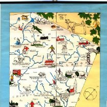
A map entitled 'Pioneer Map of Peel County' complied and designed by Jerrine Wells Kinton. Map consists of images representing important events that occurred in Peel County. The map includes Caledon, Albion, Chinguacousy, Toronto Gore and Toronto. The colourful images depict events such as the gold rush at Cataract in 1818 as well as places such as Timothy Streets 1819 in Streetsville. The top right corner of the map has a design of sugar maple leaves and a farmer with a bull. The bottom right corner has a larger design of Norway maple leaves. There is a black metal border along the top and bottom of the map. A small paper hook is found at the top for hanging. |
History |
Map created by Canadian artist Jerrine Wells Kinton (1891-1971). Kinton created a number of similar style maps highlighting other areas in Ontario. She has exhibited works throughout her career including the National Gallery of Canada, the Art Gallery of Toronto and the Royal Canadian Academy. The map highlights a number of important events, places and houses related to the history of Peel. It also shows the old boundaries and regions of villages and townships that were later amalgamated into the larger municipalities of Caledon, Brampton and Mississauga. This same map was included in the book 'A History of Peel County: To Mark Its Centenary as a Separate County 1867 -1967'. References: John A. Libby Fine Art https://www.libbygallery.com/kinton-jerrine-wells.html ArcGIS Hub https://hub.arcgis.com/search?tags=york |
Title |
Pioneer Map of Peel County |
People |
Kinton, Jerrine Wells |