Photo Record
Images
Metadata
Catalog Number |
BR2017.15.43.1 |
Object Name |
Photograph, Black-and-White |
Title |
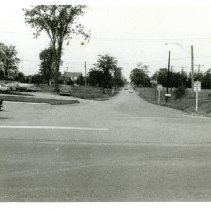
Goreway Dr. Northerly from Derry Rd. E. Aug 21, '68 |
Description |
A black and white photograph of Goreway Drive, looking north from Derry Road, taken in August 1968. The photograph shows an intersection with a paved road on the opposite side. A car is partially through the intersection to the left. The road is lined with some telephone and hydro poles. A parking lot is to the left of the image with 6 vehicles parked in it. There are two signs on the right side. There is a 0.5cm white border around the photo. On the back of the photograph is a black stamp indicating the name and address of the photographer, J. Allan Bauldry. Also marked in handwritten blue ink with the text: "Goreway Dr. Northerly from Derry Rd. E., Aug 21, '68" |
Date |
08/21/1968 |
History |
This photograph was a series of photographs captured by Town of Mississauga employee Allan Bauldry. He worked in the Works Department and took photographs during various stages of bridge and road construction in the town. Goreway Drive is a local road that travels north through Mississauga and Brampton; it is one of the main roads used in the Malton area of Mississauga. This view shows the intersection of Goreway and Derry in 1968. Goreway Drive did not extend south of Derry before 1966. At the time of this photograph, Malton's Marvin Heights and Ridgeway subdivisions were already established to the north of this intersection. References: 1966 Aerial Map www6.mississauga.ca/missmaps My Malton Community Vision Background Report, May 2015. City of Mississauga. Prepared by Urban Strategies Inc. |
Photographer |
Bauldry, Allan J. |
People |
Bauldry, Allan |
Copyright |
All rights belong to Museums of Mississauga |